


Discover Europe Guide Book for UNESCO Cultural Heritages in Europe
Copyright © 2021
Guide Book with UNESCO Cultural Heritages Sites in Europe
“produced by a common transnational project work”
Students and Teachers from the eTwinning project
“Discover Europe” produced this eBook as a common work.
This transnational collaborative work about UNESCO Cultural Heritage Sites in Europe was coordinated by the teacher
Hubert Winkler from the HTL Rankweil, Austria.
Thanks to all students and teachers who were involved in this common work and made media recherches and send pictures and texts to produce this common guide book by a mixed international student team.
Enjoy our common Guide Book about different Cultures.

Acropolis of Athens in Greece
The Acropolis of Athens and its monuments are universal symbols of the classical spirit and civilization.
The Acropolis is a group of ancient temples that were built on a high, rocky hill in Athens, Greece. The word acropolis even means ‘high city’ in Greek. Other cities have an acropolis, too, but the one in Athens is the most well-known.
The buildings were a fortress where people could escape to if the city was attacked. The Acropolis was mostly destroyed by 580 B.C. The people of Athens weren’t going to rebuild it. Temples in ancient Greece were built as places to worship gods and goddesses like Athena. The Greek builders put a giant carved statue of Athena in the temple and carved sculptures right into the walls of the temple as well.
The most famous surviving building is the Parthenon. The Parthenon was built almost 2,500 years ago and was dedicated to the goddess Athena. Athens was later ruled by Christians who made the Parthenon a church. In the 1400s Turkish forces took control of the Acropolis and made the Parthenon an Islamic Mosque. In 1687, during a war, some gunpowder stored there exploded, destroying the middle of the building.
The Erechtheum is another temple in the Acropolis. It had different rooms and was made with very fine details, including statues of women holding up the roof of its large south porch.

In this video you can watch ancient sites in Athen in Greece and you will get more informationas about the Akropolis.

Archaeological Site of Olympia in Greece
Olympia, ruined ancient sanctuary, home of the ancient Olympic Games, and former site of the massive Statue of Zeus, which had been ranked as one of the Seven Wonders of the World.
Olympia is a small town in Elis on the Peloponnese peninsula in Greece, famous for the nearby archaeological site of the same name, which was a major Panhellenic religious sanctuary of ancient Greece, where the ancient Olympic Games were held. The Olympic Games were held every four years throughout Classical antiquity, from the 8th century BC to the 4th century AD. They were restored on a global basis in 1894 in honour of the ideal of peaceful international contention for excellence. The sacred precinct was primarily dedicated to Zeus, although other gods were worshipped there. The archaeological site held over 70 significant buildings, and ruins of many of these survive, although the main Temple of Zeus survives only as stones on the ground. In ancient times it was the home of a famous temple to the god Zeus.
The original Olympic Games were held there every four years as part of a festival to honor Zeus. The United Nations Educational, Scientific and Cultural Organization (UNESCO) designated Olympia a World Heritage site in 1989. The ruins at Olympia date from at least 1600 bce. The festival of Zeus was held there every four years from 776 bce until the end of the 300s ce. By the 300s Greece was part of the Roman Empire, and Christianity would soon be the main religion. The Roman emperor Theodosius I therefore abolished festivals that honored the old Greek gods. A later emperor had the temples destroyed. Earthquakes further damaged the ruins in the 500s. Mudslides and silt from a nearby river eventually covered much of the area. This helped to preserve the site for hundreds of years. Archaeologists began digging up the ruins of Olympia in the early 1800s.

METEORA MONASTERIES in Greece
In the northwest corner of Thessaly in Greece, in the Pindos mountains, just beyond the town of Kalambaka rise sandstone peaks where monks settled in around the 11th century.
The first ones who arrived in the area to use the cliffs of Meteora for spiritual reasons were Orthodox Christian hermit-monks. They came to this place between the 9th and the 10th century to find quiet and to isolate themselves in the many caves found scattered among the cliffs. For centuries those monks lived in complete isolation. Exposed to weather elements and to all sorts of dangers they relied heavily on the help of the locals. They will regularly receive donations of food, water, clothing, wood, essential things to allow them to survive. The locals saw them as holy men who came to dwell in the area, worthy of their support.
The clifftop monasteries of Meteora are a marvelous sight to gaze at. As the Turkish raiders started their expansion towards Thessaly, hermit monks, searching for a refuge from the Turkish invasion, settled in the inaccessible rocks of Meteora. At that time, more than 20 monasteries of all sizes were constructed. With no steps and little access to the rest of the world, the monastic communities in Meteora flourished. The Meteora is a rock formation in central Greece hosting one of the largest and most precipitously built complexes of Eastern Orthodox monasteries.
Meteora, meaning ‘suspended in air’, is famous for its monasteries perched atop vertical peaks – but few know that before their construction in the 14th century, hermit monks first climbed these soaring stones to settle in the caves and hollows of the rocks. As hermits, they lived a life of solitude and isolation. By the 12th century, Meteora was home to a thriving ascetic community.
Today, the six active Meteora monasteries create a truly inspiring and sensational setting of overwhelming rock formations with these ancient monuments occupying their picks. In essence, Meteora today has become a preservation ark for the 2000-year-old Christian Orthodox creed. Today, out of initially 24 monasteries that used to exist, only 6 remain active for people to visit.


In this video you will get informations about the region Meteora and about some monasteries.
The Old Town of Corfu in Greece
Corfu is a city and a former municipality on the island of Corfu, Ionian Islands, Greece. The Old Town of Corfu, on the Island of Corfu off the western coasts of Albania and Greece, is located in a strategic position at the entrance of the Adriatic Sea, and has its roots in the 8th century BC. The three forts of the town, designed by renowned Venetian engineers, were used for four centuries to defend the maritime trading interests of the Republic of Venice against the Ottoman Empire. In the course of time, the forts were repaired and partly rebuilt several times, more recently under British rule in the 19th century. The mainly neoclassical housing stock of the Old Town is partly from the Venetian period, partly of later construction, notably the 19th century. From 1386 to 1797, Corfu was ruled by Venetian nobility; much of the city reflects this era when the island belonged to the Republic of Venice, with multi-storied buildings on narrow lanes. The Old Town of Corfu has clear Venetian influence. As a fortified Mediterranean port, Corfu’s urban and port ensemble is notable for its high level of integrity and authenticity.

Medieval City of Rhodes in Greece
When you approach the walls of Medieval Old Town of Rhodes you are about to enter the oldest inhabited medieval city in Europe.
The Order of St John of Jerusalem occupied Rhodes from 1309 to 1523 and set about transforming the city into a stronghold. It subsequently came under Turkish and Italian rule. With the Palace of the Grand Masters, the Great Hospital and the Street of the Knights, the Upper Town is one of the most beautiful urban ensembles of the Gothic period. In the Lower Town, Gothic architecture coexists with mosques, public baths and other buildings dating from the Ottoman period. Medieval buildings, mosques, traditional fountains, oriental motifs, Byzantine and Gothic churches, shops and cafeterias are scattered throughout the Old Town of Rhodes, all blending together to create a unique and picturesque whole. There are roughly 200 streets or alleys – some of them bearing no name! Getting “lost” here is not a defeat; it’s an opportunity. Whenever you feel the need to find your bearings, you may ask for “Sokratous” street, which is the closest the Medieval City comes to having a main street.

Historic Centre of Rome, ITALY
Rome, founded, according to legend, by Romulus and Remus in 753 BC. Rome was first the centre of the Roman Republic, then of the Roman Empire, and it became the capital of the Christian world in the 4th century. The World Heritage site, extended in 1990 to the walls of Urban VIII, includes some of the major monuments of antiquity such as the Forums, the Mausoleum of Augustus, the Mausoleum of Hadrian, the Pantheon, Trajan’s Column and the Column of Marcus Aurelius, as well as the religious and public buildings of papal Rome.
In the centre of Rome you can see the famous Colosseum, Roman Amphitheatre.

Vatican City in Rome, Italy
Vatican City, officially the Vatican City State in Italy is the Holy See’s independent city state, an enclave within Rome. The Vatican City State, also known as The Vatican, became independent from Italy with the Lateran Treaty (1929), and it is a distinct territory under “full ownership, exclusive dominion, and sovereign authority and jurisdiction” of the Holy See, itself a sovereign entity of international law, which maintains the city state’s temporal, diplomatic, and spiritual independence.
The Vatican is the smallest state in Europe. It has a total area of 0,44 km² and inside its wall live approximately 1000 people. As governed by the Holy See, the Vatican City State is an ecclesiastical or sacerdotal-monarchical state (a type of theocracy) ruled by the pope who is the bishop of Rome and head of the Catholic Church. Within the Vatican City are religious and cultural sites such as St. Peter’s Basilica, the Sistine Chapel, and the Vatican Museums. They feature some of the world’s most famous paintings and sculptures.
Jorge Mario Bergoglio, born 1936, was elected the 266th pope of the Roman Catholic Church in March 2013, becoming Pope Francis. He is the first pope from the Americas.


This video is a guide about the Vatican Museums.
City of Verona in Italy
The historic city of Verona was founded in the 1st century B.C. It particularly flourished under the rule of the Scaliger family in the 13th and 14th centuries and as part of the Republic of Venice from the 15th to 18th centuries. Verona has preserved a remarkable number of monuments from antiquity, the medieval and Renaissance periods, and represents an outstanding example of a military stronghold.
Verona is the city of Romeo & Juliet.
The city is situated in northern Italy at the foot of the Lessini Mountains on the River Adige. It dates from prehistoric times: a small built-up area that developed between the 4th and 3rd century BCE became a Roman municipium in the 1st century BCE after which it rose rapidly in importance. During the 5th century, Verona was occupied by the Ostrogoth Theodoric I, later by the Lombards, and in 774 by Charlemagne. In the early 12th century, it became an independent commune. It prospered under the rule of the Scaliger family and particularly under Cangrande I, falling to Venice in 1405. From 1797, it became part of the Austrian Empire and joined the Kingdom of Italy in 1866.
The core of the city consists of the Roman town nestled in the loop of the river containing one of the richest collections of Roman remains in northern Italy. Surviving remains of this era include the city gate, Porta Borsari, the remains of the Porta Leoni, the Arco dei Gavi, which was dismantled in the Napoleonic period and rebuilt next to Castelvecchio in the 1930s, the Ponte Pietra, the Roman theatre, and the Amphitheatre Arena.

Historic Centre of Florence in Italy
Florence is built on the site of an Etruscan settlement and is the symbol of the Renaissance, rose to economic and cultural pre-eminence under the Medici in the 15th and 16th centuries. Its 600 years of extraordinary artistic activity can be seen above all in the 13th-century cathedral (Santa Maria del Fiore), the Church of Santa Croce, the Uffizi and the Pitti Palace, the work of great masters such as Giotto, Brunelleschi, Botticelli and Michelangelo.
Florence is a city in Central Italy and the capital city of the Tuscany region. It is the most populated city in Tuscany, with around 400 000 inhabitants. Florence was a centre of medieval European trade and finance and one of the wealthiest cities of that era. The city is noted for its culture, Renaissance art and architecture and monuments.

Venice and its Lagoon, Italy
Venice was founded in the 5th century and spread over 118 small islands, Venice became a major maritime power in the 10th century.
Venice, Italian Venezia, was a major seaport, and capital of both the provincia (province) of Venezia and region of Veneto, nothern Italy. An island city, it was once the centre of a maritime republic. It was the greatest seaport in late medieval Europe and the continent’s commercial and cultural link to Asia. The whole city is an extraordinary architectural masterpiece in which even the smallest building contains works by some of the world’s greatest artists such as Giorgione, Titian, Tintoretto, Veronese and others. Venice is a city in northeastern Italy and the capital of the Veneto region. It is built on a group of 118 small islands that are separated by canals and linked by over 400 bridges. The islands are in the shallow Venetian Lagoon, an enclosed bay lying between the mouths of the Po and the Piave rivers. The name is derived from the ancient Veneti people who inhabited the region by the 10th century BC.
Very famous are the Doges’ Palace and the Piazza San Marco.


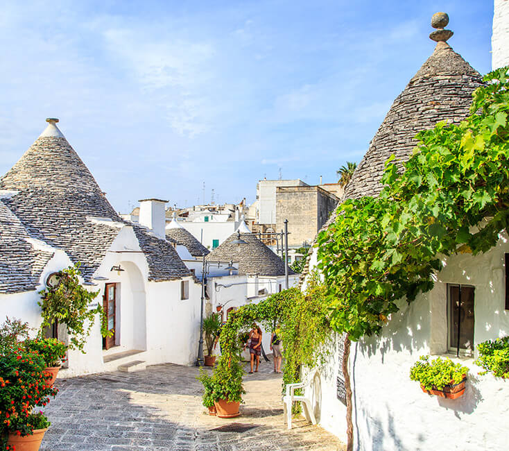
The Trulli in ALBEROBELLO in Italy

Saint Sophia Cathedral in Kyiv / Kiev, Ukraine
St. Sophia Cathedral, Holy Wisdom of God Cathedral, St. Sophia in Kyiv (Kiev) Ukraine is a Christian cathedral in the center of Kyiv with a Byzantine architecture. The structure of the Cathedral has 5 naves, 5 apses, and 13 cupolas. The cathedral is named after the 6th-century Hagia Sophia (Holy Wisdom) cathedral in Constantinople (present-day Istanbul), which was dedicated to the Holy Wisdom rather than to a specific saint named Sophia. It is a monument of Ukrainian architecture and monumental painting of the second decade of the 11th (1011–1018). This is one of the few surviving buildings of the Kyivan Rus’ time. This is one of the most important Christian shrines in Western Europe, the historical center of Kyiv Metropolis. St. Sophia Cathedral in Kyiv is a symbolic monument. If the universal symbol of the Church of Wisdom has been and remains St. Sophia in Constantinople, the St. Sophia in Kyiv has been such symbol for the Eastern Slavonic world. For centuries, it has been the main shrine of Rus’-Ukraine, the core of higher wisdom that harmonizes the life of the people, protects and lights its fate. St. Sophia Cathedral is a real memorial of the Christianization of Rus’-Ukraine, monument of princely piety, richness and glory, state’s wisdom and generosity. It preserves excellent ancient architecture and the most complete in the world ensemble of original mosaics and frescoes of the 11th century.

L’viv /Lviv – the Ensemble of the Historic Centre in Ukraine
Lviv is the largest city in western Ukraine and the seventh-largest city in the country overall, with a population of 720,383. Lviv is one of the main cultural centres of Ukraine. The city of L”viv, founded in the late Middle Ages, was a flourishing administrative, religious and commercial centre for several centuries. The medieval urban topography has been preserved virtually intact (in particular, there is evidence of the different ethnic communities who lived there), along with many fine Baroque and later buildings. After the German-Soviet invasion of Poland in 1939, Lviv became part of the Soviet Union, and in 1944–46 there was a population exchange between Poland and Soviet Ukraine. In 1991, it became part of the independent nation of Ukraine. Lviv was the centre of the historical regions of Red Ruthenia and Galicia. The historical heart of the city, with its old buildings and cobblestone streets, survived Soviet and German occupations during World War II largely unscathed. Lviv is also the home of many cultural institutions, including a philharmonic orchestra and the Lviv Theatre of Opera and Ballet.

Residence of Bukovinian and Dalmatian Metropolitans in Ukraine
Chernivtsi is a city in western Ukraine. It is situated on the upper course of the Prut River, and is the administrative center of Chernivtsi Oblast (province), which includes the Ukrainian part of Bukovina.
The Residence of Bukovinian and Dalmatian Metropolitans represents a masterful synergy of architectural styles built by Czech architect Josef Hlavka from 1864 to 1882.
The property, an outstanding example of 19th-century historicist architecture, also includes a seminary and monastery and is dominated by the domed, cruciform Seminary Church with a garden and park. The complex expresses architectural and cultural influences from the Byzantine period onward and embodies the powerful presence of the Orthodox Church during Habsburg rule, reflecting the Austro-Hungarian Empire policy of religious tolerance. Situated within the boundaries of the town of Chernivtsi, on the river promontory, named Mount Dominic, the architectural ensemble comprises the former Residence of the Metropolitans with its St. Ivan of Suceava Chapel; the former seminary and Seminary Church, and the former monastery with its clock tower within a garden and landscaped park. The Residence, with a dramatic fusion of architectural references, expresses the 19th century cultural identity of the Orthodox Church within the Austro-Hungarian Empire during a period of religious and cultural toleration. The Residence of the Bukovinian and Dalmatian Metropolitans was declared a National Park in 1945.

Castle Kamianets – Podilskyi in Ukraine
Kamianets-Podilskyi is a city on the Smotrych River in western Ukraine, to the north-east of Chernivtsi, in the historic region of Podolia. Formerly the administrative center of the Khmelnytskyi Oblast, the city is now the administrative center of the Kamianets-Podilskyi Raion (district) within the Khmelnytskyi Oblast (province). The city itself is also designated as a separate district within the region. Current population has been estimated as 98 970.
The castle was built on top of a peninsula carved by Smotrych winding river, forming a natural defense system for the castle and the Kamianets-Podilskyi’s Old City; a bridge over the river is the only entrance to the castle. The name of the castle is attributed to the root Kamin ‘, from the Slavic word for stone. Initially, the fort was built to protect the bridge that connects the medieval city with the mainland. Its location on a strategic transport junction. Archaeological research indicates that there was a castle in the tenth and thirteenth centuries the fortress consisted of the historic center of Kamianets-Podilskyi fortified by King Casimir IV Jagiello.

Rila Monastery in Bulgaria
Rila Monastery is the most important spiritual and literary center of the Bulgarian national revival, with an uninterrupted history from the Middle Ages until present times. Reconstruction work was required following a fire, and sections of the monastery, a new church and other structures date to the 18th century.
Rila Monastery was founded in the 10th century by St John of Rila, a hermit canonized by the Orthodox Church. His ascetic dwelling and tomb became a holy site and were transformed into a monastic complex which played an important role in the spiritual and social life of medieval Bulgaria. Destroyed by fire at the beginning of the 19th century, the complex was rebuilt between 1834 and 1862. A characteristic example of the Bulgarian Renaissance (18th–19th centuries), the monument symbolizes the awareness of a Slavic cultural identity following centuries of occupation.
In its complicated ten-century history the Rila monastery has been the hub of a strong spiritual and artistic influence over the Eastern Orthodox world during medieval times (11th-14th c.). Under Ottoman rule (1400-1878) the monastery influenced the development of the culture and the arts of all Christian nations within the Ottoman Empire. With its architecture, frescos etc. it represents a masterpiece of the creative genius of the Bulgarian people.
Architectural styles have been preserved on the property as historical monuments of considerable time span (11th-19th c.). The basic architectural appearance is now one of the peak examples of building craftsmanship of the Balkan peoples from the early 19th c. As such it has exerted considerable influence on architecture and aesthetics within the Balkan area.
Rila Monastery is considered a symbol of the 19th Century Bulgarian Renaissance which imparted Slavic values upon Rila in trying to reestablish an uninterrupted historic continuity.

Ancient City of Nessebar in Bulgaria
Situated on a rocky peninsula on the Black Sea, the more than 3,000-year-old site of Nessebar was originally a Thracian settlement (Menebria). At the beginning of the 6th century BC, the city became a Greek colony. The city’s remains, which date mostly from the Hellenistic period, include the acropolis, a temple of Apollo, an agora and a wall from the Thracian fortifications. Among other monuments, the Stara Mitropolia Basilica and the fortress date from the Middle Ages, when this was one of the most important Byzantine towns on the west coast of the Black Sea. Wooden houses built in the 19th century are typical of the Black Sea architecture of the period.
The Ancient city of Nessebar is a unique example of a synthesis of the centuries-old human activities in the sphere of culture; it is a location where numerous civilizations have left tangible traces in single homogeneous whole, which harmoniously fit in with nature. The different stages of development of its residential vernacular architecture reflect the stages of development of the architectural style on the Balkans and in the entire East Mediterranean region. The urban structure contains elements from the second millennium BC, from Ancient Times and the Medieval period.
The medieval religious architecture, modified by the imposition of the traditional Byzantine forms, illustrates ornamental ceramics art, the characteristic painted decoration for this age. The town has served for over thousands of years as remarkable spiritual hearth of Christian culture.

Boyana Church in Bulgaria
Located on the outskirts of Sofia, Boyana Church consists of three buildings. The eastern church was built in the 10th century, then enlarged at the beginning of the 13th century by Sebastocrator Kaloyan, who ordered a second two storey building to be erected next to it. The frescoes in this second church, painted in 1259, make it one of the most important collections of medieval paintings. The ensemble is completed by a third church, built at the beginning of the 19th century. This site is one of the most complete and perfectly preserved monuments of east European medieval art.
There are several layers of wall paintings in the interior from the 11th, 13th, 15-17th and 19th centuries which testify to the high level of wall painting during the different periods. The paintings with the most outstanding artistic value are those from 13th century. Whilst they interpret the Byzantine canon, the images have a special spiritual expressiveness and vitality and are painted in harmonious proportions.
From an architectural point of view, Boyana Church is a pure example of a church with a Greek cross ground-plan with dome, richly decorated facades and decoration of ceramic elements. It is one of the most remarkable medieval monuments with especially fine wall paintings.
The Boyana Church is composed of three parts, each built at a different period – 10 century, 13th century and 19th century which constitute a homogenous whole.

Rock-Hewn Churches of Ivanovo in Bulgaria
In the valley of the Roussenski Lom River, in north east Bulgaria, a complex of rock-hewn churches, chapels, monasteries and cells developed in the vicinity of the village of Ivanovo. This is where the first hermits had dug out their cells and churches during the 12th century. The 14th-century murals testify to the exceptional skill of the artists belonging to the Tarnovo School of painting. Most churches date from the 13th century. They are situated in the picturesque Rusenski Lom valley. The valley is a karst region covered with meanders and cliffs, some are tens of metres high.
The frescos of the Ivanovo churches reveal an exceptional artistry and a remarkable artistic sensitivity for 14th century painting and Bulgarian medieval art; they are an important achievement in the Christian art of South-Eastern Europe. Posterior to the Khora monastery mosaics (Karia Djami) of 1303 – 10, these frescoes, by their very expressiveness surpass any other historical monuments discovered, characteristic of the Palaeologues style. Neo-classical in spirit and in elements of their subjects, the frescoes represent a departure from the canons of Byzantine iconography. They show close ties with expressive Hellenistic art and a clear preference for the nude, the landscape, an architectural background in a composition, drama, an emotional atmosphere – qualities which combine to make an exceptional masterpiece of the Tarnovo school of painting and monumental art.
The five historical monuments in this group (chapels, churches, etc.), dating from the 13th and 14th centuries, serve as examples that pave the way for the distinctive character development, and mastery in the art of the Second Bulgarian State /1187-1396/. The richness, the variety of the cells, chapels, churches, monastery complexes, the original architectural solutions – all set in a magnificent natural environment – confirm the value of this extraordinary historical grouping.
Many churches, chapels, monasteries and cells were cut into the natural rock along the Rusenski Lom river, during the 13-14th centuries. The “Church” frescoes reveal an exceptional artistry and a remarkable artistic sensitivity for 14th century painting and Bulgarian medieval art; they are an important achievement in the Christian art of South-Eastern Europe. Neo-classical in spirit and in elements of their subjects, the frescoes represent a departure from the canons of Byzantine iconography. They show close ties with expressive Hellenistic art and a clear preference for the nude, the landscape, an architectural background in a composition, drama, an emotional atmosphere – qualities which combine to make an exceptional masterpiece.


Churches and monasteries in the Village of Arbanasi in Bulgaria
The Village of Arbanasi, one of Bulgaria’s most actractive settlements, is located on a high plateau 4km northeast of Veliko Tarnovo. Traditional architectural style is maintained throughout the village, and fortified houses from the 17th century are well-preseved and open to the public as museums. You can also visit many preserved churches and monasteries from the 16th and 17th centuries.
Arbanasi owes most of its glory to its Orthodox churches. Seven Christian churches were constructed, extended and icon painted time and again during the period the from the mid-14th century to the late 18th century. Most prominent among them is the Bishopric Nativity Church. It has a complex architectural composition.
Arbanasi is a village in Veliko Tarnovo Municipality, Veliko Tarnovo Province of central northern Bulgaria, set on a high plateau between the larger towns of Veliko Tarnovo (four kilometres away) and Gorna Oryahovitsa. It is known for the rich history and large number of historical monuments, such as 17th- and 18th-century churches and examples of Bulgarian National Revival architecture, which have turned it into a popular tourist destination. The name of the village is derived from the word Arbanas meaning “Albanian” in Bulgarian of the medieval period. A 17th-century inscription in Greek from the Church of the Nativity of Christ, Arbanasi. The Bulgarian Orthodox population in the Ottoman Empire until 1870 was under the spiritual authority of the Greek Patriarchate of Constantinople. Arbanasi experienced strong Greek cultural influence for centuries. There was a Greek school and divine services were in Greek (at that time Bulgarian Orthodox Church was banned by the Ottoman authorities and Bulgarian orthodox population officially had to be served by the Greek Orthodox Church). This, however, did not reflect the local population’s national self-consciousness, as Arbanasi residents took part in the organized armed struggle of Bulgarians that ultimately led to the Liberation of Bulgaria from Ottoman rule as a consequence of the Russo-Turkish War of 1877-78.
Landmarks in Arbanasi are the Arbanasi Monastery of the Dormition of the Mother of God (17th-18th century), Monastery of Saint Nicholas (17th-18th century), Church of the Nativity of Christ (c. 15th-17th century), Church of Saints Archangels Michael and Gabriel (16th-18th century)
Church of Saint Athanasius (17th century), Church of Saint George (17th century).

Madara Rider in Bulgaria
The Madara Rider or horseman, representing the figure of a knight triumphing over a lion, is carved into a 100-m-high cliff near the village of Madara in north-east Bulgaria. Madara was the principal sacred place of the First Bulgarian Empire before Bulgaria’s conversion to Christianity in the 9th century. The inscriptions beside the sculpture tell of events that occurred between AD 705 and 801.
The Madara Rider is a unique relief, an exceptional work of art, created during the first years of the formation of the Bulgarian State, at the beginning of the 8th century. It is the only relief of its kind, having no parallel in Europe. It has survived in its authentic state, with no alternation in the past or the present.
It is outstanding not only as a work of Bulgarian sculpture, with its characteristically realist tendencies, but also as a piece of historical source material dating from the earliest years of the establishment of the Bulgarian state. The inscriptions around the relief are, in fact, a chronicle of important events concerning the reigns of very famous Khans: Tervel, Kormisos and Omurtag.
The Madara Rider is an exceptional work of art dating from the beginning of the 8th century. It is the only relief of its kind, having no parallel in Europe.

Churches of Moldova
The painted churches. These eight churches of northern Moldavia, built from the late 15th century to the late 16th century, their external walls covered in fresco paintings, are masterpieces inspired by Byzantine art. They are authentic and particularly well preserved. Far from being mere wall decorations, the paintings form a systematic covering on all the facades and represent complete cycles of religious themes.Their exceptional composition, the elegance of the characters, and the harmony of the colors blend perfectly with the surrounding countryside. The interior and exterior walls of the Church of the Suceviţa Monastery are entirely decorated with mural paintings of the 16th century, and this church is the only one to show a representation of the ladder of St John Climacus.
The churches with external mural paintings of northern Moldavia, built from the late 15th century to the late 16th century, are masterpieces inspired by Byzantine art. These eight churches of northern Moldavia are unique in Europe. They are authentic and particularly well preserved. Far from being mere wall decorations, the paintings form a systematic covering on all the facades and represent complete cycles of religious themes. Their exceptional composition, the elegance of the characters, and the harmony of the colours blend perfectly with the surrounding countryside.
The external paintings of the churches of Northern Moldavia cover all the facades. They embody a unique and homogeneous artistic phenomenon, directly inspired by Byzantine art. They are masterpieces of mural painting, and are of outstanding aesthetic value in view of their consummate chromatism and the remarkable elegance of the figures. They present cycles of events taken from the Bible and the Holy Scriptures, in the Orthodox Christian tradition.

Soroca Fortress in Moldova
Soroca is a city and municipality in Moldova, situated on the Dniester river about 160 km north of Chișinău. It is the administrative center of the Soroca District. The Soroca Fortress is a historic fort in th modern-day city of Soroca.
Located on the site of a 15th-century Genoese wooden fort, Soroca Fortress boasts an impressive stone edifice, and is a must-see for history buffs. At the center of Soroca city, situated on the right bank of the Dniester river, the fortress was a fortified trading post built by Stephen the Great in 1499 to protect his goods from Polish and Hungarian forces. Wander the halls of this castle tower, and take in the views of the castle town and surrounding countryside from the fortress walls.


Struve Geodetic Arc in Moldova
Struve Geodetic Arc (in Belarus, Estonia, Finland, Latvia, Lithuania, Norway, Republic of Moldova, Russian Federation, Sweden, Ukraine) is an UNESCO Heritage Site.
The Struve Arc is a chain of survey triangulations stretching from Hammerfest in Norway to the Black Sea, through 10 countries and over 2,820 km. These are points of a survey, carried out between 1816 and 1855 by the astronomer Friedrich Georg Wilhelm Struve, which represented the first accurate measuring of a long segment of a meridian. This helped to establish the exact size and shape of the planet and marked an important step in the development of earth sciences and topographic mapping. It is an extraordinary example of scientific collaboration among scientists from different countries, and of collaboration between monarchs for a scientific cause. The original arc consisted of 258 main triangles with 265 main station points. The listed site includes 34 of the original station points, with different markings, i.e. a drilled hole in rock, iron cross, cairns, or built obelisks.

Hattusha – the Hittite Capital in Turkey
The archaeological site of Hattusha, former capital of the Hittite Empire, is notable for its urban organization, the types of construction that have been preserved (temples, royal residences, fortifications), the rich ornamentation of the Lions’ Gate and the Royal Gate, and the ensemble of rock art at Yazilikaya. The city enjoyed considerable influence in Anatolia and northern Syria in the 2nd millennium B.C.
Hattusha: the Hittite Capital is located in Boğazkale District of Çorum Province, in a typical landscape of the Northern Central Anatolian Mountain Region. It lies at the south end of the Budaközü Plain, on a slope rising approximately 300 m above the valley, and is divided by the Kızlarkayası creek into the lower city in the north and the upper city in the south.
The ruins of the upper city’s fortification form a double wall with more than a hundred towers and, as far as is known today, five gateways: two in the west, the Lion’s Gate in the south-west, the King’s Gate in the south-east and a procession gate, the Sphinx Gate in the south of the city. The latter is located on top of a high artificial bastion with stone-plastered slopes, with two staircases leading to the gateway at the top and an arched stone tunnel running underneath. The impressive ruins of fortifications, placed on rocky peaks in the centre of the Upper City, bear witness to the complexity of Hittite rock masonry, and the longest known Hittite hieroglyphic inscription from the Hittite Empire can be found in the Upper City at Nişantepe.
The best-preserved ruin of a Hittite Temple from the 13th century B.C., known as Great Temple, is located in the Lower City. Other temples of similar date and shape, albeit generally smaller, are situated in the Upper City, which mostly consisted of a temple city for the gods and goddesses of the Hittite and Hurrian pantheon. The remains of a densely inhabited city district were unearthed in the Lower City, where their foundations and arrangement can still be seen in the area north from Great Temple.
The famous rock sanctuary of Yazılıkaya, which is an open-air temple with two natural chambers cut into the bedrock, lies 2 km northeast of the capital, on a slope of a mountain barrier. The walls of the rock chambers are covered with the richest and most striking samples of Hittite relief art, featuring gods and goddesses and the figures of the Great King Tuthaliya IV.

Historic Areas of Istanbul, Turkey
With its strategic location on the Bosphorus peninsula between the Balkans and Anatolia, the Black Sea and the Mediterranean, Istanbul has been associated with major political, religious and artistic events for more than 2,000 years. Its masterpieces include the ancient Hippodrome of Constantine, the 6th-century Hagia Sophia and the 16th-century Süleymaniye Mosque, all now under threat from population pressure, industrial pollution and uncontrolled urbanization.
Strategically located on the Bosphorus peninsula between the Balkans and Anatolia, the Black Sea and the Mediterranean, Istanbul was successively the capital of the Eastern Roman Empire, and the Ottoman Empire and has been associated with major events in political history, religious history and art history for more than 2,000 years. The city is situated on a peninsula which is surrounded by the Golden Horn (Haliç), a natural harbor on the north, the Bosphorus on the east and the Marmara Sea on the south. The Historic Peninsula, on which the former Byzantium and Constantinople developed, was surrounded by ancient walls, built initially by Theodosius in the early fifth century.
The Outstanding Universal Value of Istanbul resides in its unique integration of architectural masterpieces that reflect the meeting of Europe and Asia over many centuries, and in its incomparable skyline formed by the creative genius of Byzantine and Ottoman architects.
The distinctive and characteristic skyline of Istanbul was built up over many centuries and encompasses the Hagia Sophia whose vast dome reflects the architectural and decorative expertise of the 6th century, the 15th century Fatih complex and Topkapi Palace – that was continually extended until the 19th century, the Süleymaniye Mosque complex and Sehzade Mosque complex, works of the chief architect Sinan, reflecting the climax of Ottoman architecture in the 16th century, the 17th century Blue Mosque and the slender minarets of the New Mosque near the port completed in 1664.
The four areas of the property are the Archaeological Park, at the tip of the Historic peninsula; the Suleymaniye quarter with Suleymaniye Mosque complex, bazaars and vernacular settlement around it; the Zeyrek area of settlement around the Zeyrek Mosque (the former church of the Pantocrator), and the area along both sides of the Theodosian land walls including remains of the former Blachernae Palace. These areas display architectural achievements of successive imperial periods also including the 17th century Blue Mosque, the Sokollu Mehmet Pasha Mosque, the 16th century Şehzade Mosque complex, the 15th century Topkapi Palace, the hippodrome of Constantine, the aqueduct of Valens, the Justinian churches of Hagia Sophia, St. Irene, Küçük Ayasofya Mosque (the former church of the Sts Sergius and Bacchus), the Pantocrator Monastery founded under John II Comnene by Empress Irene; the former Church of the Holy Saviour of Chora with its mosaics and paintings dating from the 14th and 15th centuries; and many other exceptional examples of various building types including baths, cisterns, and tombs.
The Historic Areas of Istanbul include monuments recognised as unique architectural masterpieces of Byzantine and Ottoman periods such as Hagia Sophia, which was designed by Anthemios of Tralles and Isidoros of Miletus in 532-537 and the Suleymaniye Mosque complex designed by architect Sinan in 1550-1557.


In this video you can see some attractions from Istanbul.
This video will show you the UNESCO World Heritage Sites in Turkey.
Great Mosque and Hospital of Divriği in Turkey
Great Mosque and Hospital of Divriği:
this region of Anatolia was conquered by the Turks at the beginning of the 11th century. In 1228–29 Emir Ahmet Shah founded a mosque, with its adjoining hospital, at Divrigi. The mosque has a single prayer room and is crowned by two cupolas. The highly sophisticated technique of vault construction, and a creative, exuberant type of decorative sculpture – particularly on the three doorways, in contrast to the unadorned walls of the interior – are the unique features of this masterpiece of Islamic architecture.
Located on the slopes below the castle of Divriği, Sivas Province in central eastern Turkey, the Great Mosque and Hospital of Divriği is a remarkable building combining a monumental hypostyle mosque with a two storey hospital, which includes a tomb. Founded by the Mengücekide emir Ahmed Shah following the victory of the Seljuk Turks over the Byzantine army at the battle of Malazgirt in 1071, the mosque is dominated externally by the hexagonal, pointed roofed dome over its mihrab (prayer niche), a cupola over the ablutions basin in the centre of the prayer hall and elaborately carved monumental stone portals on the north and west. Internally, four rows of four piers create five naves roofed by a variety of intricately carved stone vaults. The adjoining hospital, the Darush-shifa, was founded by Ahmet Shah’s wife Turan Melek and designed by the architect Hurrem Shah, in 1228-1229. It is entered via a monumental, elaborately carved stone portal on the west, leading into a double height atrium formed by four massive piers supporting a dome with an oculus over a central pool, around which are located the hospital rooms.
The highly sophisticated technique of vault construction and a creative, exuberant type of decorative sculpture – particularly on the three doorways, in contrast to the unadorned walls of the interior – are the unique features of this masterpiece of Islamic architecture. The variety of the carved decoration indicates that is was carried out by different groups of craftsmen. The main characteristic of the designs featured in the portals is their uniqueness: each is distinct from other decorations. As well as portals, all bases, shafts and capitals of the columns, and the inner surface of the dome and the vaults, were decorated in a distinct and unique style. There are no other examples of the three-dimensional and intricate geometric styles and flowing figures of plants. The vaulting of the hospital room is comparable in scientific achievement to that of the prayer hall of the Mosque, and shares the splendid unity of the Great Mosque.
A unique artistic achievement, this cultural property in itself represents one of Islamic architecture’s most beautiful built spaces.

Göreme National Park and the Rock Sites of Cappadocia in Turkey
In a spectacular landscape, entirely sculpted by erosion, the Göreme valley and its surroundings contain rock-hewn sanctuaries that provide unique evidence of Byzantine art in the post-Iconoclastic period. Dwellings, troglodyte villages and underground towns – the remains of a traditional human habitat dating back to the 4th century – can also be seen there.
Located on the central Anatolia plateau within a volcanic landscape sculpted by erosion to form a succession of mountain ridges, valleys and pinnacles known as “fairy chimneys” or hoodoos, Göreme National Park and the Rock Sites of Cappadocia cover the region between the cities of Nevşehir, Ürgüp and Avanos, the sites of Karain, Karlık, Yeşilöz, Soğanlı and the subterranean cities of Kaymaklı and Derinkuyu. The area is bounded on the south and east by ranges of extinct volcanoes with Erciyes Dağ (3916 m) at one end and Hasan Dağ (3253 m) at the other. The density of its rock-hewn cells, churches, troglodyte villages and subterranean cities within the rock formations make it one of the world’s most striking and largest cave-dwelling complexes. Though interesting from a geological and ethnological point of view, the incomparable beauty of the decor of the Christian sanctuaries makes Cappadocia one of the leading examples of the post-iconoclastic Byzantine art period.
It is believed that the first signs of monastic activity in Cappadocia date back to the 4th century at which time small anchorite communities, acting on the teachings of Basileios the Great, Bishop of Kayseri, began inhabiting cells hewn in the rock. In later periods, in order to resist Arab invasions, they began banding together into troglodyte villages or subterranean towns such as Kaymakli or Derinkuyu which served as places of refuge.
Cappadocia, a semi-arid region in central Turkey, is known for its distinctive “fairy chimneys,” tall, cone-shaped rock formations clustered in Monks Valley, Göreme and elsewhere. Other notables sites include Bronze Age homes carved into valley walls by troglodytes (cave dwellers) and later used as refuges by early Christians. The 100m-deep Ihlara Canyon houses numerous rock-face churches.

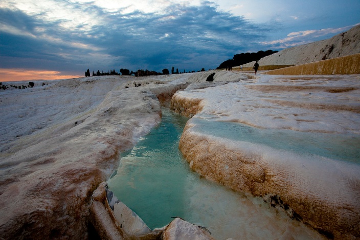
Pamukkale in Turkey
Pamukkale in Aegean Turkey is also called the “Cotton Castle”, because of the white, cottony appearance of the mineral bath spas that abound the province, which is rich in calcium. Known as a “spa town” since the Roman era, tourists travel to Pamukkale to relax in warm, soothing and therapeutic waters in the myriad spas.
Pamukkale is a small place, but it has remarkable spots to make your trip memorable such as the ruins of Hierapolis (ancient spa town), Sacred Pool (scattered marble columns add to the charm of this warm, calcium-dense pool), Travertines (calcium deposit terraces), Roman Theater and the archaeological Museum.
Many years ago, Greeks and Romans discovered the curative properties of the warm mineral springs that are found in Pamukkale. Predictably, these springs attracted droves of tourists to the place, but not only to seek therapeutic comforts, but also to see the magnificence of the hardened calcium bicarbonate cascading over the cliffs.
Pamukkale, meaning “cotton castle” in Turkish, is a natural site in Denizli Province in southwestern Turkey. The area is famous for a carbonate mineral left by the flowing of thermal spring water. It is located in Turkey’s Inner Aegean region, in the River Menderes valley, which has a temperate climate for most of the year. The ancient Greco-Roman city of Hierapolis was built on top of the travertine formation, which is in total about 2,700 metres long, 600 m wide and 160 m high. It can be seen from the hills on the opposite side of the valley in the town of Denizli, 20 km away. Known as Pamukkale (Cotton Castle) or ancient Hierapolis (Holy City), this area has been drawing visitors to its thermal springs since the time of Classical antiquity. The Turkish name refers to the surface of the shimmering, snow-white limestone, shaped over millennia by calcite-rich springs. Dripping slowly down the mountainside, mineral-rich waters collect in and cascade down the mineral terraces, into pools below. Legend has it that the formations are solidified cotton (the area’s principal crop) that giants left out to dry.
People have visited area for thousands of years, due to the attraction of the thermal pools. As recently as the mid-20th century, hotels were built over the ruins of Hierapolis, causing considerable damage. An approach road was built from the valley over the terraces, and motor bikes were allowed to go up and down the slopes.

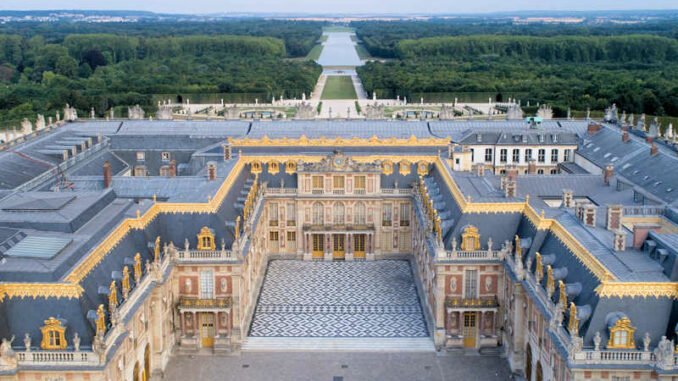
Palace and Park of Versailles in France
The Palace of Versailles was the principal residence of the French kings from the time of Louis XIV to Louis XVI. Embellished by several generations of architects, sculptors, decorators and landscape architects, it provided Europe with a model of the ideal royal residence for over a century.
Located in the Île-de-France region, south-west of Paris, privileged place both of residence and the exercise of power of the French monarchy from Louis XIV to Louis XVI, the Palace and Park of Versailles, built and embellished by several generations of architects, sculptors, painters, ornamentalists and landscape artists, represented for Europe for more than a century, the perfect model of a royal residence. The architectural planning and the majestic composition of the landscape form a close symbiosis, serving as a setting for the magnificence of the interior decorations of the apartments.
The inscribed property includes the zone enclosing the prestigious ensemble of the Palace, the Trianon châteaux and their gardens, as well as a narrow band of land offering the perspective from the extremity of the Grand Canal. It is the result of a century and a half of work commanded by the kings of France and entrusted to its greatest artists.
The strongest imprint has been left by Louis XIV, who started by enlarging the small brick and stone château built by his father, Louis XIII, in 1624. A first addition occurred after 1661 under the direction of Le Vau, in a still strongly italianite style. After 1678, Versailles was once again considerably enlarged and radically modified by Jules Hardouin-Mansart, who successfully introduced a sober, colossal, homogenous and majestic architecture, now inseparable from the memory of the Sun King. The famous Galerie des Glaces, between the Salon de la Guerre and that of the Paix, is the masterpiece of the Neo-classical and typically French style, called Louis XIV. The Orangerie and the Grand Trianon are also the work of Mansart, who was assisted by Robert de Cotte in the construction of the Royal Chapel.
The creations at Versailles during the 18th century are among the most perfect and most celebrated works of the Louis XV and Louis XVI styles: the Petit Trianon by Jacques-Ange Gabriel, the decoration of the appartments of Louis XV by Verbeckt and Rousseau, and the appartments and the Hameau of Marie-Antoinette by Mique.
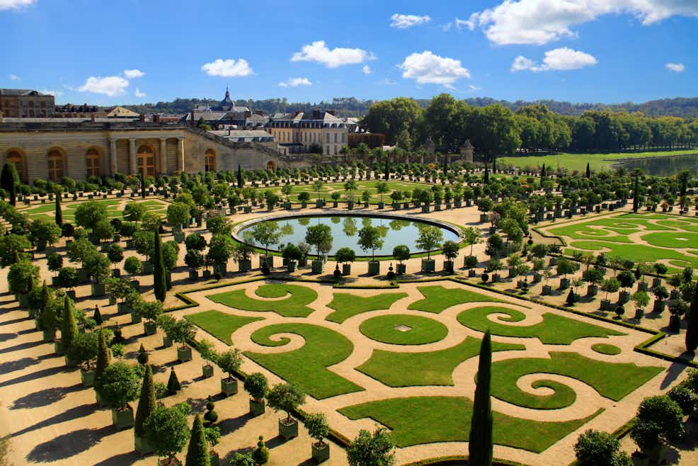
The gardens that complete the Palace, developed during the construction process of the ensemble, were designed by Le Nôtre, creator of the typology of the French-style garden, an open system of axial pathways extending as far as the eye can see and punctuated with flowers and low hedges, flower beds, small streams, large lakes and fountains.
The ensemble of the Palace and Park of Versailles constitutes a unique artistic realisation, by virtue not only of its size but also of its quality and originality.
Versailles exercised great influence throughout Europe from the end of the 17th century to the end of the 18th century. Wren incorporated reminiscences of Versailles into Hampton Court, Schlüter into Berlin, in designing the façades of the Palais Royal. “Little Versailles” have sprung up: Nymphenburg, Schleissheim, Karlsruhe, Würtzbourg, Postdam, Stockholm, etc. Le Nôtre’s gardens, designed by the architect himself, or by his imitators are innumerable: from Windsor to Cassel, to the Granja, Sweden, Denmark and Russia.


In this video you can discover the Palace of Versailles.
Mont-Saint-Michel and its Bay in France
Mont Saint-Michel is one of the most important sites of medieval Christian civilization.

Perched on a rocky islet in the midst of vast sandbanks exposed to powerful tides, at the limit between Normandy and Brittany, stands “Wonder of the West”, a Gothic-style Benedictine abbey dedicated to the Archangel St Michel, and the village that grew up in the shadow of its walls. Built between the 11th and 16th centuries, the abbey is a technical and artistic tour de force, having had to adapt to the problems posed by this unique natural site. Thus, the practical and aesthetic solutions inscribed in the stones of the edifice are henceforth inseparable from its natural environment.
This Benedictine abbey, founded in 966, was erected on a sanctuary dedicated to the Archangel Michel since 708 and conserves some vestiges of the Romananesque period. The older part of the present abbey, the small pre-Romanesque church with a double nave, Notre-Dame-sous-terre, in granite masonry and flat bricks, dates back undoubtedly to the 10th century. The contribution of the Romanesque period is still visible in the nave of the abbey church, whose crossing is supported by the rock summit, and in a group of conventual staggered buildings (the chaplaincy or gallery of Aquilon, the covered gallery of the monks of which the vault, constructed after 1103, would be one of the earliest examples of ribbed vaulting).
But it is the masters of the Gothic period who, benefiting as best they could from the restricted area, invented the high walls, the soaring masses, the open volumes, the airy pinacles and the sharp silhouette of the rock. The new body of the conventual buildings, built from 1204, merits the name of “Merveille” (Marvel) for the elegance of its conception. Above the chaplaincy of the 12th century, it comprises the celebrated rooms known as the ‘Hôtes’ and the ‘Chevaliers’ and, on the uppermost floor, in addition to the vast body of the refectory, the cloister with colonnettes grouped in five, open on one side to the sea. Among the many later additions, mention should be made of the flamboyant choir of the abbey church, begun in 1448 to replace the Romanesque choir which had previously collapsed.
The Mont-Saint-Michel, sanctuary located in a difficult place of access, in accordance with the tradition of places of worship dedicated to Saint Michel, place of pilgrimage frequented throughout the Middle Ages, and later seat of a Benedictine abbey of strong intellectual influence, is in its most characteristic aspects, one of the most important sites of Christian civilization in the Middle Ages.
Through the unique combination of the natural site and the architecture, the Mont-Saint-Michel constitutes a unique aesthetic success.
Mont-Saint-Michel is an unequalled ensemble, as much because of the co-existence of the abbey and its fortified village within the confined limits of a small island, as for the originality of the placement of the buildings which accord with its unforgettable silhouette.

Pont du Gard, the Roman Aqueduct in France
The Pont du Gard is an ancient Roman aqueduct bridge built in the first century AD to carry water over 50 km (31 mi) to the Roman colony of Nemausus (Nîmes). It crosses the river Gardon near the town of Vers-Pont-du-Gard in southern France. The Pont du Gard is the highest of all Roman aqueduct bridges, as well as one of the best preserved. It was added to UNESCO’s list of World Heritage sites in 1985 because of its historical importance.
The aqueduct was used as a bridge across the river for centuries. Part of the columns supporting the upper parts of the aqueduct was carved out to allow for cattle, carts, and foot traffic to cross more easily. In the 18th century, a bridge was built alongside to aqueduct to better facilitate traffic crossing the river. The bridge is still in place, and the damage done to the aqueduct when used as a bridge was repaired.

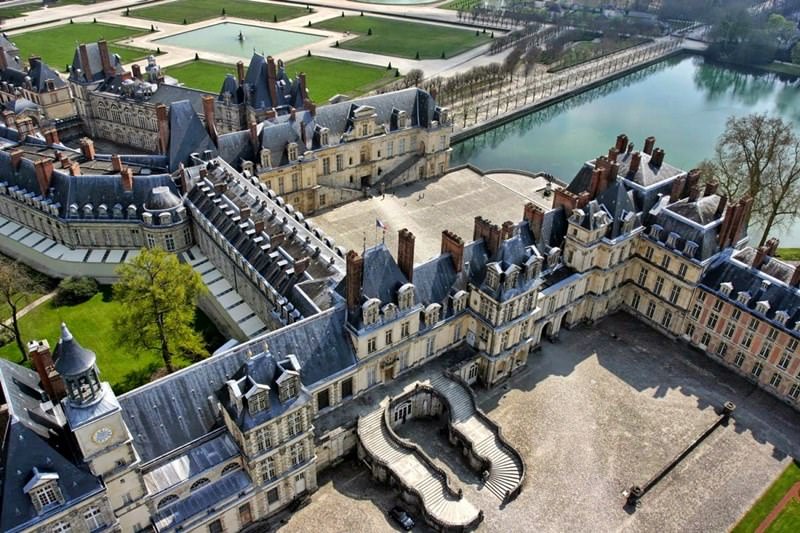
Palace and Park of Fontainebleau in France
Used by the kings of France from the 12th century, the medieval royal hunting lodge of Fontainebleau, standing at the heart of a vast forest in the Ile-de-France, was transformed, enlarged and embellished in the 16th century by François I, who wanted to make a ‘New Rome’ of it. Surrounded by an immense park, the Italianate palace combines Renaissance and French artistic traditions.
The Palace of Fontainebleau, a royal residence of the French sovereigns until the 19th century, was constantly maintained and enriched with artistic additions and is also associated with important historical events that occurred there, such as the repeal of the Edict of Nantes, in 1685, and the abdication of Napoleon I in 1814.
The architecture and decor of the Palace of Fontainebleau strongly influenced the evolution of art in France and Europe. The Italian artists called upon by the king, painters, sculptors and architects, decisively and lastingly oriented French Renaissance art, to which they gave its most prestigious and precious examples.
The Palace and the Park of Fontainebleau, a major royal residence for four centuries, are associated with events in French history of exceptional universal importance such as the repeal of the Edict of Nantes by Louis XIV in 1685 and the abdication of the Emperor Napoleon I in 1814.
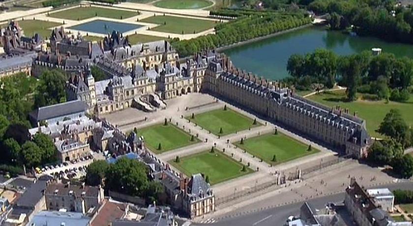
Used by the kings of France from the 12th century, the hunting lodge of Fontainebleau, standing in the heart of the vast forest of the Ile-de-France in the Seine-et-Marne region, was transformed, enlarged and embellished in the 16th century by King François I, who wanted to make it a “new Rome”. Surrounded by an immense park, the palace, to which notable Italian artists contributed, combines Renaissance and French artistic traditions. The need to expand and decorate this immense palace created the conditions for the survival of a true artistic centre.
The construction of the palace began in 1528. The modifications undertaken later by François I’s successors and carried out on different scales until the 19th century have left their imprint on the physionomy of the present complex, which today comprises five courtyards placed in an irregular manner and surrounded by an ensemble of buildings and gardens.
The first building was constructed between 1528 and 1540 under the direction of Gilles Le Breton, the architect of the Oval Courtyard in the eastern wing of the palace. From 1533 to 1540, Rosso Fiorentino worked on the painted decor and the stucco in the François I gallery, achieving an ambitious iconographic programme where themes illustrating monarchy through Greco-Roman fables and myths. Francesco Primaticcio casted the most famous bronzes of antique Rome for decoration. He consecrated the most productive phase of his career to Fontainebleau, where he worked on the frescoes of the Salle de Bal, the room of the Duchesse d’Etampes and the Galerie d’Ulysse. Very few of the rooms that he decorated have survived, but his creations are remembered thanks to drawings and engravings that considerably influenced his time. Nicolo dell’Abbate collaborated with him.
Fontainebleau is associated with other artists: a Hercules of Michelangelo was raised on a plinth in the Cour de la Fontaine; Benvenuto Cellini created his Nymphe of Fontainebleau for the Porte Dorée; Serlio drew up the plans for the different parts of the palace and conceived the entrance to the Fontaine Belle-Eau with its rustic grotto and telamons.

The Loire Valley between Sully-sur-Loire and Chalonnes in France
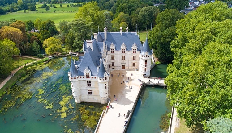
The Loire Valley is an outstanding cultural landscape of great beauty, containing historic towns and villages, great architectural monuments (the châteaux), and cultivated lands formed by many centuries of interaction between their population and the physical environment, primarily the river Loire itself.
The property of the Loire Valley between Sully-sur-Loire and Chalonnes is located in the regions of the Centre-Val-de-Loire and Pays-de-la-Loire. This cultural landscape covers a section of the Middle course of the 280km river, from Sully-sur-Loire, east of Orléans up to Chalonnes, west of Angers, including the minor and major beds of the river.
It is formed by many centuries of interaction between the river, the land that it irrigates and the populations established there throughout history.
The Loire has been a major communication and commercial axis since Gallo-Roman times up until the 19th century, thus encouraging the economic development of the valley and its towns. Witness to the many works destined to channel the river for navigation and the protection of humankind and the land against flooding, are the ports or dyke systems, sometimes in stonework, that punctuate the river.
The Loire has formed as much the rural landscapes, in the organization of the land and the types of culture (market gardening, vines), as the urban landscapes. Human settlements, isolated farms, villages and towns, translate both the physical characteristics of the different parts of the river and their historical evolution. The tufa and slate architecture, the troglodyte dwellings, the urban fabric, all reflect this. In the boundary of the property, the banks of the Loire are punctuated by villages and towns among which are Sully, Orléans, Blois, Amboise, Tours and Saumur.
The political and social history of France and Western Europe in the Middle Ages as well as during the Renaissance, the period when the Loire Valley was a seat of royal power, is illustrated by the buildings and castles that have made it famous, such as Chambord, Chenonceau, Amboise, Blois and Azay-le-Rideau. Benedictine abbeys first of all, then medieval fortresses, they were transformed during the Renaissance into country houses for recreation and pleasure, with gardens and vistas open to the countryside. The Loire Valley also contains a series of large, important Romanesque churches, witness to the expression of faith of the sovereigns and the people: Saint-Benoît-sur-Loire, Fontevraud, Cunault, the ogival churches of Blois and Candes.
In the 15th and 16th centuries, the Loire Valley constituted a major cultural area for encounters and influences between the Italian Mediterranean, France and Flanders, and participated in the development of garden art and the emergence of interest in the landscape.


Strasbourg, Grande-Île and Neustadt in France
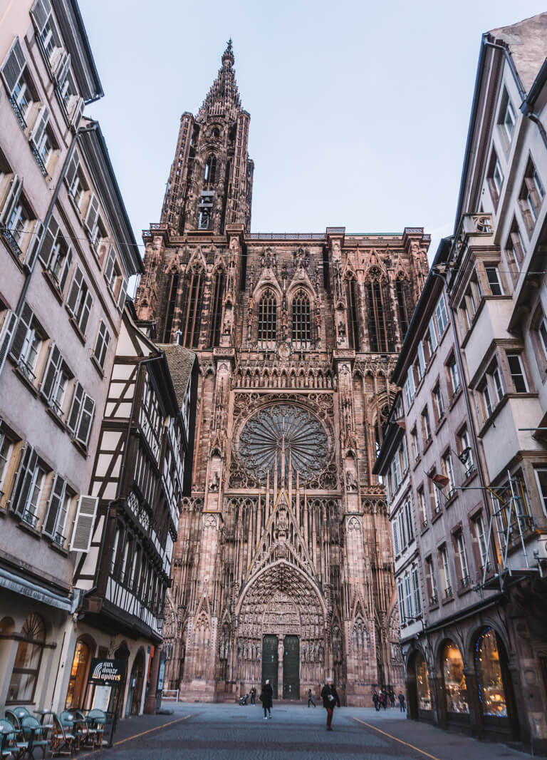
The initial property, inscribed in 1988 on the World Heritage List, was formed by the Grande-Île, the historic centre of Strasbourg, structured around the cathedral. The extension concerns the Neustadt, new town, designed and built under the German administration (1871-1918). The Neustadt draws the inspiration for its urban layout partially from the Haussmannian model, while adopting an architectural idiom of Germanic inspiration. This dual influence has enabled the creation of an urban space that is specific to Strasbourg, where the perspectives created around the cathedral open to a unified landscape around the rivers and canals.
The Grande-Île and the Neustadt form an urban ensemble that is characteristic of Rhineland Europe, with a structure that centres on the cathedral, a major masterpiece of Gothic art. Its distinctive silhouette dominates the ancient riverbed of the Rhine and its man-made waterways. Perspectives created around the cathedral give rise to a unified urban space and shape a distinctive landscape organized around the rivers and canals.
The French and Germanic influences have enabled the composition of a specific urban space combining constructions reflecting major significant periods of European history: Roman Antiquity, the Middle Ages and the Rhineland Renaissance, French 18th century classicism, and then the 19th and early 20th centuries which saw the emergence of a modern city, the capital and symbol of the new German state.

Historic Fortified City of Carcassonne in France
Carcassonne is located in the south of France about 80 kilometres east of Toulouse. Its strategic location between the Atlantic Ocean and the Mediterranean Sea has been known since the neolithic era.

Since the pre-Roman period, a fortified settlement has existed on the hill where Carcassonne now stands. In its present form it is an outstanding example of a medieval fortified town, with its massive defences encircling the castle and the surrounding buildings, its streets and its fine Gothic cathedral. Carcassonne is also of exceptional importance because of the lengthy restoration campaign undertaken by Viollet-le-Duc, one of the founders of the modern science of conservation.
Carcassonne, town, capital of Aude département, Occitanie region, southwestern France, southeast of Toulouse, near the eastward bend of the Aude River, which divides the city into two towns, the Ville Basse and the Cité. The Cité has the finest remains of medieval fortifications in Europe. On the summit of an isolated hill rearing abruptly on the Aude’s right bank, the site of the Cité was occupied as early as the 5th century BCE by the Iberians, then by Gallo-Romans.

Historic Centre of Vienna in Austria

Picture: The Imperial Palace, known as the Hofburg.
Vienna developed from early Celtic and Roman settlements into a Medieval and Baroque city, the capital of the Austro-Hungarian Empire. It played an essential role as a leading European music centre, from the great age of Viennese Classicism through the early part of the 20th century. The historic centre of Vienna is rich in architectural ensembles, including Baroque castles and gardens, as well as the late-19th-century Ringstrasse lined with grand buildings, monuments and parks.
Vienna, situated on the Danube River in the eastern part of Austria, developed from early Celtic and Roman settlements into a medieval and Baroque city, eventually becoming the capital of the Austro-Hungarian Empire. It played an essential role as the leading European music centre, hosting major personalities in the development of music from the 16th to the 20th centuries, particularly Viennese Classicism and Romanticism, consolidating Vienna’s reputation as the ‘musical capital’ of Europe. Vienna is also rich in architectural ensembles, particularly Baroque mansions and gardens as well as the late 19th-century Ringstrasse ensemble lined with grand buildings, monuments, and parks. The property consists of the city’s medieval core (based on the Roman settlement), the principal Baroque ensembles with their axial layouts, and the Gründerzeit constructions from the beginning of the modern period.
At the beginning of the 12th century the settlement here expanded beyond the Roman defences, which were demolished. During the Ottoman conflicts in the 16th and 17th centuries, the medieval town’s walls, which surrounded a much larger area, were rebuilt and provided with bastions. This remained the core of Vienna until the medieval walls were demolished in the second half of the 19th century. The inner city contains a number of medieval-era buildings, including the Schottenkloster, the oldest monastery in Austria, the churches of Maria am Gestade (one of the main Gothic structures), Michaelerkirche, Minoritenkirche and Minoritenkloster from the 13th century, and St Stephen’s Cathedral, which dates from the 14th and 15th centuries. The same period also saw the construction of civic ensembles, such as initial parts of the Hofburg Palace. Whereas the monastic complexes were generally built of stone, becoming part of the defences of the medieval city, the residential quarters were of timber and suffered frequent fires.
In 1683, Vienna became the capital of the Habsburg Empire and developed rapidly, becoming an impressive Baroque city. The Baroque character was expressed particularly in the large palace layouts such as the Belvedere Palace and garden ensemble. A growing number of new palaces were built by noble families, many existing medieval buildings, churches, and convents were altered and given Baroque features, and additions were made to representative administrative buildings. Several historic Viennese buildings are now associated with the residences of important personalities such as Mozart, Beethoven, and Schubert, when the city played an essential role as a leading European centre for music.


If you want to know more about Vienna, you can watch this travel guide video.
This is a virtuel guide for the Chultural Heritage Palace Schönbrunn in Vienna.
Palace and Gardens of Schönbrunn in Vienna
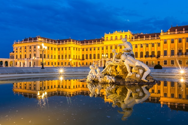
From the 18th century to 1918, Schönbrunn was the residence of the Habsburg emperors. It was designed by the architects Johann Bernhard Fischer von Erlach and Nicolaus Pacassi and is full of outstanding examples of decorative art. Together with its gardens, the site of the world’s first zoo in 1752, it is a remarkable Baroque ensemble.
The site of the Palace and Gardens of Schönbrunn is outstanding as one of the most impressive and well preserved Baroque ensembles of its kind in Europe. Additionally, it is a potent material symbol of the power and influence of the House of Habsburg over a long period of European history, from the end of the 17th to the early 20th century.
It is impossible to separate the gardens from the palace, of which they form an organic extension: this is an excellent example of the concept of Gesamtkunstwerk, a masterly fusion of many art forms.
A small hunting lodge and later summer residence of the Habsburg family was rebuilt after total destruction during the last Turkish attack in 1683. During construction work the project was expanded into an Imperial summer residence of the court. As such it represents the ascent and the splendour of the Habsburg Empire. At the peak of Habsburg power at the beginning of the 18th century, when imperial Vienna following the Turkish reflected its regained significance in spectacular examples of newly developing Baroque art, Schönbrunn was one of the most important building projects of the capital and residency.
The ample Baroque gardens with their buildings (Gloriette, Roman ruins etc.) and statuary testify to the palace’s imperial dimensions and functions. The original intention, when they were laid out in the 18th century, was to combine the glorification of the House of Habsburg with a homage to nature. The Orangery on the east side of the main palace building is, at 186 m, the longest in the world. The Great Palm House is an impressive iron-framed structure, 114 m long and divided into three Sections, erected in 1880 using technology developed in England.

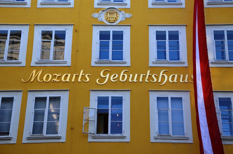
Historic Centre of Salzburg, Austria
Salzburg has managed to preserve an extraordinarily rich urban fabric, developed over the period from the Middle Ages to the 19th century when it was a city-state ruled by a prince-archbishop. Its Flamboyant Gothic art attracted many craftsmen and artists before the city became even better known through the work of the Italian architects Vincenzo Scamozzi and Santini Solari, to whom the centre of Salzburg owes much of its Baroque appearance. This meeting-point of northern and southern Europe perhaps sparked the genius of Salzburg’s most famous son, Wolfgang Amadeus Mozart, whose name has been associated with the city ever since.


In this video you can see 10 favorite places in Austria.
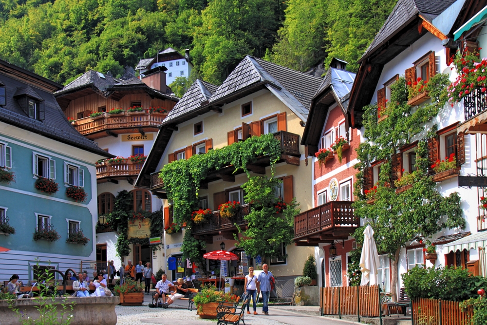
Hallstatt-Dachstein / Salzkammergut Cultural Landscape in Austria
Human activity in the magnificent natural landscape of the Salzkammergut began in prehistoric times, with the salt deposits being exploited as early as the 2nd millennium BC. This resource formed the basis of the area’s prosperity up to the middle of the 20th century, a prosperity that is reflected in the fine architecture of the town of Hallstatt.


Tower of London, United Kingdom
The Tower of London, officially Her Majesty’s Royal Palace and Fortress of the Tower of London, is a historic castle on the north bank of the River Thames in central London. Most of the early Norman castles were built from timber, but by the end of the 11th century a few, including the Tower of London, had been renovated or replaced with stone. Its buildings and grounds served historically as a royal palace, a political prison, a place of execution, an arsenal, a royal mint, a menagerie, and a public records office. It was founded towards the end of 1066 as part of the Norman Conquest. The White Tower, which gives the entire castle its name, was built by William the Conqueror in 1078 and was a resented symbol of oppression, inflicted upon London by the new ruling elite. The castle was also used as a prison from 1100 until 1952. As a whole, the Tower is a complex of several buildings set within two concentric rings of defensive walls and a moat. There were several phases of expansion, mainly under kings Richard I, Henry III, and Edward I in the 12th and 13th centuries. The general layout established by the late 13th century remains despite later activity on the site. Today, the Tower of London is one of the country’s most popular tourist attractions. One of the highlights are the magnificent Crown Jewels.


Stonehenge, in Salisbury Plain in Wiltshire, United Kingdom
Stonehenge is one of the most famous ancient landmarks in the United Kingdom. There must have been a spiritual reason why Neolithic and Bronze Age people put so much effort into building this Stone Circle. Stonehenge is a prehistoric monument in England, 3 km west of Amesbury. It consists of an outer ring of vertical Sarsen standing stones, each around 4.0 m high, 2.1 m wide, and weighing around 25 tons, topped by connecting horizontal lintel stones. Inside is a ring of smaller bluestones. Two types of stone are used at Stonehenge – the larger sarsens and the smaller ‘bluestones’. The sarsens were erected in two concentric arrangements – an inner horseshoe and an outer circle – and the bluestones were set up between them in a double arc. Inside these are free-standing trilithons, two bulkier vertical Sarsens joined by one lintel. The whole monument, now ruinous, is oriented towards the sunrise on the summer solstice. It was built in several stages: the first monument was an early henge monument, built about 5,000 years ago, and the unique stone circle was erected in the late Neolithic period about 2500 BC. Archaeologists believe it was constructed from 3000 BC to 2000 BC. The surrounding circular earth bank and ditch, which constitute the earliest phase of the monument, have been dated to about 3100 BC.

Alhambra, Generalife and Albayzín, Granada in Spain
Rising above the modern lower town, the Alhambra and the Albaycín, situated on two adjacent hills, form the medieval part of Granada. To the east of the Alhambra fortress and residence are the magnificent gardens of the Generalife, the former rural residence of the emirs who ruled this part of Spain in the 13th and 14th centuries. The residential district of the Albaycín is a rich repository of Moorish vernacular architecture, into which the traditional Andalusian architecture blends harmoniously.


These two videos will give you an introduction to some famous World Heritage Sites in Europe.
Traveling is learning about other cultures, even your travel was virtual.
“There is a kind of magicness about going far away and then coming back all changed.”
The international mixed project group from different schools, students and teachers in the eTwinning project “Discover Europe” wish you for your future amazing travels in Europe.
Published: Jun 8, 2021
Latest Revision: Jun 11, 2021
Ourboox Unique Identifier: OB-1169990
Copyright © 2021
![]()