


The tricolour, but Orange

Copyright © 2019
Ireland also known as the Republic of Ireland, is a country in north-western Europe occupying 26 of 32 counties of the island of Ireland. The capital and largest city is Dublin, which is located on the eastern side of the island. Around a third of the country’s population of 4.8 million people resides in the greater Dublin area. The sovereign state shares its only land border with Northern Ireland, a part of the United Kingdom. It is otherwise surrounded by the Atlantic Ocean, with the Celtic Sea to the south, St George’s Channel to the south-east, and the Irish Sea to the east. It is a unitary, parliamentary republic.

The legislature, the Oireachtas, consists of a lower house, Dáil Éireann, an upper house, Seanad Éireann, and an elected President (Uachtarán) who serves as the largely ceremonial head of state, but with some important powers and duties. The head of government is the Taoiseach (PrimeMinister, literally ‘Chief’, a title not used in English), who is elected by the Dáil and appointed by the President; the Taoiseach in turn appoints other government ministers.
The state was created as the Irish Free State in 1922 as a result of the Anglo-Irish Treaty. It had the status of Dominion until 1937 when a new constitution was adopted, in which the state was named “Ireland” and effectively became a republic, with an elected non-executive president as head of state.
It was officially declared a republic in 1949, following the Republic of Ireland Act 1948. Ireland became a member of the United Nations in December 1955. It joined the European Economic Community (EEC), the predecessor of the European Union, in 1973. The state had no formal relations with Northern Ireland for most of the twentieth century, but during the 1980s and 1990s the British and Irish governments
worked with the Northern Ireland parties towards a resolution to “the Troubles”. Since the signing of the Good Friday Agreement in 1998, the Irish government and Northern Ireland Executive have co-operated on a number of policy areas under the North-South Ministerial Council created by
the Agreement.
Ireland ranks among the top ten wealthiest countries in the world in terms of GDP per capita, and as the tenth most prosperous country in the world according to The Legatum Prosperity Index 2015. After joining the EEC, Ireland enacted a series of liberal economic policies that resulted in rapid economic growth. The country achieved considerable prosperity between the years of 1995 and 2007, which became known as the Celtic Tiger period. This was halted by an unprecedented financial crisis that began in 2008, in conjunction with the concurrent global economic crash.
However, as the Irish economy was the fastest growing in the EU in 2015, Ireland is again quickly ascending league tables comparing wealth and prosperity internationally. For example, in 2015, Ireland was ranked as the joint sixth (with Germany) most developed country in the world by the United Nations Human Development Index. It also performs well in several national performance metrics, including freedom of the press, economic freedom and civil liberties. Ireland is a member of the European Union and is a founding member of the Council of Europe and the OECD. The Irish government
has followed a policy of military neutrality through non-alignment since immediately prior to World War II and the country is consequently not a member of NATO, although it is a member of Partnership for Peace.
The 1922 state, comprising 26 of the 32 counties of Ireland, was “styled and known as the Irish Free State”.
The Constitution of Ireland, adopted in 1937, provides that “the name of the State is Éire, or, in the English language, Ireland”. Section 2 of the Republic of Ireland Act 1948 states, “It is hereby declared that the description of the State shall be the Republic of Ireland.” The 1948 Act does not name the state as “Republic of Ireland”, because to have done so would have put it in conflict with the Constitution.
The government of the United Kingdom used the name “Eire” (without the diacritic) and, from 1949, “Republic of Ireland”, for the state; it was not until the 1998 Good Friday Agreement that it used the name “Ireland”.
As well as “Ireland”, “Éire” or “the Republic of Ireland”, the state is also referred to as “the Republic”, “Southern Ireland” or “the South”. In an Irish republican context it is often referred to as “the Free State” or “the 26 Counties”.
From the Act of Union on 1 January 1801, until 6 December 1922, the island of Ireland was part of the United Kingdom of Great Britain and Ireland. During the Great Famine, from 1845 to 1849,
the island’s population of over 8 million fell by 30%. One million Irish died of starvation and/or disease and another 1.5 million emigrated, mostly to the United States. This set the pattern of emigration for the century to come, resulting in constant population decline up to the 1960s. From 1874, and particularly under Charles Stewart Parnell from 1880, the Irish Parliamentary Party gained prominence. This was firstly through widespread agrarian agitation via the Irish Land League, that won land reforms for tenants in the form of the Irish Land Acts, and secondly through its attempts to achieve Home Rule, via two unsuccessful bills which would have granted Ireland limited national autonomy. These led to “grass-roots” control of national affairs, under the Local
Government Act 1898, that had been in the hands of landlord-dominated grand juries of the Protestant Ascendancy.
Home Rule seemed certain when the Parliament Act 1911 abolished the veto of the House of Lords, and John Redmond secured the Third Home Rule Act in 1914. However, the Unionist movement had been growing since 1886 among Irish
Protestants after the introduction of the first home rule bill, fearing discrimination and loss of economic and social privileges if Irish Catholics achieved real political power. In the late 19th and early 20th century unionism was particularly strong in parts of Ulster,
where industrialisation was more common in contrast to the more agrarian rest of the island, and where the Protestant population was more prominent, with a majority in four counties. Under the
leadership of the Dublin-born Sir Edward Carson of the Irish Unionist Party and the Ulsterman Sir James Craig of the Ulster Unionist Party, unionists became strongly militant in order to oppose “the Coercion of Ulster”. After the Home Rule Bill passed parliament in May 1914, to avoid rebellion with Ulster, the British Prime Minister H. H. Asquith introduced an Amending Bill reluctantly conceded to by the Irish Party leadership.
This provided for the temporary exclusion of Ulster from the workings of the bill for a trial period of six years, with an as yet undecided new set of measures to be introduced for the area to be temporarily excluded.
The state extends over an area of about five-sixths (70,273 km2 or 27,133 sq mi) of the island of Ireland (84,421 km2 or 32,595 sq mi), with Northern Ireland constituting the remainder. The island is bounded to the north and west by the Atlantic Ocean and to the northeast by the North Channel. To the east, the Irish Sea connects to the Atlantic Ocean via St George’s Channel and the Celtic Sea to the southwest.
The western landscape mostly consists of rugged cliffs, hills and mountains. The central lowlands are extensively covered with glacial deposits of clay and sand, as well as significant areas of bogland and several lakes. The highest point is Carrauntoohil (1,038 m or 3,406 ft), located in the MacGillycuddy’s Reeks mountain range in the southwest. River Shannon, which traverses the central lowlands, is the longest river in Ireland at 386 kilometres or 240 miles in length. The west coast is more rugged than the east, with numerous islands, peninsulas, headlands and bays.
Ireland is the least forested country in Europe. Until the end of the Middle Ages, the land was heavily forested with native
trees such as oak, ash, hazel, birch, alder, willow, aspen, elm, rowan, yew and Scots pine. The growth of blanket bog and the extensive clearing of woodland for farming are believed to be the main causes of deforestation. Today, only about 10% of Ireland is woodland, most of which is non-native conifer plantations, and only 2% of which is native woodland. The average woodland cover in European countries is over 33%. Ideal soil conditions, high rainfall and a mild climate give Ireland the highest growth rates for forests in Europe. Hedgerows, which are traditionally used to define land boundaries, are an important substitute for woodland habitat, providing refuge for native wild flora and a wide range of insect, bird and mammal species.
Glendalough valley in County Wicklow
Agriculture accounts for about 64% of the total land area. This has resulted in limited land to preserve natural habitats, in particular for larger wild mammals with greater territorial requirements. The long history of agricultural production coupled with modern agricultural methods, such as pesticide and fertiliser use, has placed pressure on biodiversity.
The Atlantic Ocean and the warming influence of the Gulf Stream affect weather patterns in Ireland. Temperatures differ regionally, with central and eastern areas tending to be more extreme. However, due to a temperate oceanic climate,
temperatures are seldom lower than −5 °C (23 °F) in winter or higher than 26 °C (79 °F) in summer. The highest temperature recorded in Ireland was 33.3 °C (91.9 °F) on 26 June 1887 at Kilkenny Castle in Kilkenny, while the lowest temperature recorded was −19.1 °C (−2.4 °F) at Markree Castle in Sligo. Rainfall is more prevalent during winter months and less so during the early months of summer. Southwestern areas experience the most rainfall as a result of south westerly winds, while Dublin receives the least. Sunshine duration is highest in the southeast of the country.

The far north and west are two of the windiest regions in Europe, with great potential for wind energy generation. Ireland normally gets between 1100 and 1600 hours of sunshine each year, most areas averaging between 3.25 and 3.75 hours a day. The sunniest months are May and June, which average between 5 and 6.5 hours per day over most of the country. The extreme southeast gets most sunshine, averaging over 7 hours a day in early summer. December is the dullest month, with an average daily sunshine ranging from about 1 hour in the north to almost 2 hours in the extreme southeast. The sunniest summer in the 100 years from 1881 to 1980 was 1887, according to measurements made at the Phoenix Park in Dublin; 1980 was the dullest.
Ireland is a constitutional republic with a parliamentary system of government. The Oireachtas is the bicameral national parliament composed of the President of Ireland and the two Houses of the Oireachtas: Seanad Éireann (Senate) and Dáil Éireann (House of Representatives). Áras an Uachtaráin is the official residence of the President of Ireland, while the houses of the Oireachtas meet at Leinster House in Dublin.
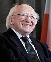
The President serves as head of state, and is elected for a seven-year term and may be re-elected once. The President is primarily a figurehead, but is entrusted with certain constitutional powers with the advice of the Council of State. The office has absolute discretion in some areas, such as referring a bill to the Supreme Court for a judgment on its constitutionality. Michael D. Higgins became the ninth President of Ireland on 11 November 2011.
The Taoiseach (Prime Minister) serves as the head of government and is appointed by the President upon the nomination of the Dáil. Most Taoisigh have served as the
leader of the political party that gains the most seats in national elections. It has become customary for coalitions to form a government, as there has not been a single-party government since 1989. Leo Varadkar succeeded Enda Kenny as Taoiseach on 14 June 2017.
The Seanad is composed of sixty members, with eleven nominated by the Taoiseach, six elected by two universities, and 43 elected by public representatives from panels of candidates established on a vocational basis. The Dáil has 158 members (Teachtaí Dála) elected to represent multi-seat constituencies under the system of proportional representation and by means of the single transferable vote.
The Government is constitutionally limited to fifteen members. No more than two members can be selected from the Seanad, and the Taoiseach, Tánaiste (Deputy Prime Minister) and Minister for Finance must be members of the Dáil. The Dáil must be dissolved within five years after its first meeting following the previous election, and a general election for members of the Dáil must take place no later than thirty days after the dissolution. According to the Constitution of Ireland, parliamentary elections must be held at least every seven years, though a lower limit may be set by statute law. The current government is a Fine Gael led minority government led by Leo Varadkar as Taoiseach and Simon Coveney as Tánaiste.

It is supported by a number of independents including Shane Ross and former Senator Katherine Zappone. The minority government is held in place by a confidence and supply deal with Fianna Fáil. Opposition parties in the current Dáil are Fianna Fáil, Sinn Féin, the Labour Party, Solidarity–People Before Profit, Social Democrats, Workers and Unemployed Action, the Green Party as well as a number of independents.
Ireland has been a member state of the European Union since 1973, but has chosen to remain outside the Schengen Area. Citizens of the United Kingdom can freely enter the country without a passport due to the Common Travel Area, which is a passport-free zone comprising the islands of Ireland, Great Britain, the Isle of Man and the Channel Islands. However, some identification is required at airports and seaports.
This book is produced by students and is exclusively for teaching purposes.
Published: Jul 3, 2019
Latest Revision: Jul 3, 2019
Ourboox Unique Identifier: OB-662421
Copyright © 2019
![]()
 Skip to content